- Home
- About
- Map
- Trips
- Bringing Boat West
- Migration West
- Solo Motorcycle Ride
- Final Family XC Trip
- Colorado Rockies
- Graduates' XC Trip
- Yosemite & Nevada
- Colorado & Utah
- Best of Utah
- Southern Loop
- Pacific Northwest
- Northern Loop
- Los Angeles to NYC
- East Coast Trips
- Martha's Vineyard
- 1 Week in Quebec
- Southeast Coast
- NH Backpacking
- Martha's Vineyard
- Canadian Maritimes
- Ocracoke Island
- Edisto Island
- First Landing '02
- Hunting Island '02
- Stowe in Winter
- Hunting Island '01
- Lake Placid
- Chesapeake
- Provincetown
- Hunting Island '00
- Acadia in Winter
- Boston Suburbs
- Niagara Falls
- First Landing '99
- Cape Hatteras
- West Coast Trips
- Burning Man
- Utah Off-Roading
- Maui
- Mojave 4WD Course
- Colorado River Rafting
- Bishop & Death Valley
- Kauai
- Yosemite Fall
- Utah Off-Road
- Lost Coast
- Yosemite Valley
- Arizona and New Mexico
- Pescadero & Capitola
- Bishop & Death Valley
- San Diego, Anza Borrego, Joshua Tree
- Carmel
- Death Valley in Fall
- Yosemite in the Fall
- Pacific Northwest
- Utah Off-Roading
- Southern CA Deserts
- Yosemite & Covid
- Lake Powell Covid
- Eastern Sierra & Covid
- Bishop & Death Valley
- Central & SE Oregon
- Mojave Road
- Eastern Sierra
- Trinity Alps
- Tuolumne Meadows
- Lake Powell Boating
- Eastern Sierra
- Yosemite Winter
- Hawaii
- 4WD Eastern Sierra
- 4WD Death Valley +
- Southern CA Deserts
- Christmas in Tahoe
- Yosemite & Pinnacles
- Totality
- Yosemite & Sierra
- Yosemite Christmas
- Yosemite, San Diego
- Yosemite & North CA
- Seattle to Sierra
- Southwest Deserts
- Yosemite & Sierra
- Pacific Northwest
- Yosemite & South CA
- Pacific Northwest
- Northern California
- Southern Alaska
- Vancouver Island
- International Trips
- Index
- Tips
- Books
- Photos/Videos
- Search
- Contact
Mohave Road - Fort Piute (mile 23.7) to just shy of Marl Springs (mile 77), CA
Thursday, October 18, 2018 - 2:45pm by Lolo
53 miles and 4 hours from our last stop - 1 night stay
Travelogue
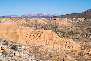 Piute Gorge OverlookThe next morning we had what would become our go-to breakfast before hitting the road - coffee and a Nature Valley Oats ‘n Honey granola bar. For some reason, neither of us felt like making oatmeal.
We followed the bumpy babyhead road back out to the main road and turned right (south) and followed the power lines for about a mile and a half before turning right (west).
At mile 31.4, we took another diversion and drove a short distance north, past an old corral and onto the Piute Gorge Overlook. From there, we took a hike down into a canyon in search of the Piute Spring. Although we never found the spring itself, it wasn’t too tough to realize we were near, as the dry barren desert was replaced with the lush greenery of willows and cottonwoods along the Piute Creek. I can see why this area was so important for the people that braved the crossing of this desert.
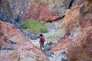 Hike down to Piute SpringsWe continued west through the Lanfair Valley, happily following the reliable cairns across numerous washes. The vegetation along this stretch was mostly creosote bushes, yuccas, and mesquite.
After about mile 35, the first Joshua trees appeared. They were widely scattered at first, but as the road began to climb, they became more dense. They are happiest above 4,000 feet. The happier they are, the more interesting and numerous their branches are.
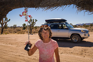 Lolo and the Penny CanAt Mile 41.4, we came to the famous “penny can” hanging out by a wire from the limb of a Joshua tree. We dutifully stopped to add our pennies (which we had placed in the cupholder at home in anticipation of this moment) to the collection already in the can. According to Dennis Casebier, the author of our guide, as the Mojave Road was being developed into a recreational trail in 1983, this can appeared with a few pennies inside. Tradition then took over, and to this day travelers still stop to make their tongue-in-cheek contribution to Mojave Road maintenance. Hey, it all adds up.
At mile 42.0, we crossed the Ivanpah-Lanfair Road, a well-maintained county road that could deliver us to civilization in about 20 minutes - Goffs, 17 miles to the south, and Ivanpah,19 miles to the north. We forged on passing my favorite desert vegetation - Joshua trees, cholla cactus, and yucca.
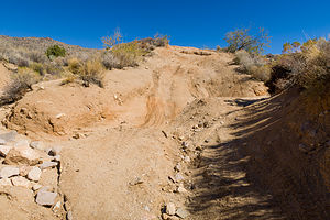 Watson WashSoon we came to mile 49.5, where the Mojave Road drops down along a very steep hill with deep gullies carved out by flash floods into Watson Wash. Herb had watched enough hours of YouTube videos of people driving the Mojave Road to know that this was the place we could get ourselves into the most trouble. We both got out of the car at the top of the hill to reconnoiter the situation. Fortunately, we were in agreement - it wasn’t worth the risk. We took the short bypass along Cedar Canyon Road and rejoined the Mojave Road at mile 50.5 - so technically, we would do the whole Mojave Road to the river, except for 1 mile.
Shortly after we got back on the Mojave Road, at mile 51, we turned off into the Rock Springs parking lot, where I visited my first porcelain toilet since starting our journey. However, this spot had more historical significance than that in that it was the location of the second spring along the east to west route across the Mojave, conveniently placed about 25 miles from the last (Piute Springs).
As we had learned at Piute Springs, wherever there is a water source in the desert, there is a military outpost to protect it. Camp Rock Spring was established in 1866 and manned for two years until the U.S. Mail was taken off the Mojave Road and the presence of an Army was no longer needed.
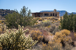 Rock House at Rock SpringsAt the edge of the parking lot stood an interesting stone structure called the Rock House, made from rocks in the surrounding area, so it blended quite nicely into the environment. It was built in 1929 by a man named Bert George Smith, who was recovering from exposure to poison gas during World War I. He thought the desert environment would help him regain his health. Well, I guess he was right, because although we was expected to not survive long, he lived in this house for 25 years. Beyond the house was a short 1 ⅓-mile loop hike down a ravine to the spring with lovely desert views along the way.
We had hardly gotten driving again before we came to the Government Holes (mile 52.5), another source of water quite close to Rock Springs, which was a well dug in 1859 by teamsters employed by Phineas Banning. Although travelers did make use of this well, it was mainly used for cattle operations, as cattle grazing was quite extensive in the Mojave right up until 1990 when the National Park Service acquired ownership of the ranches and shut down the water. The only remnants of this period in the Mojave Road’s history are a windmill, water tanks, and a corral. There was also a gunfight here in 1925 where two men, Matt Burts and J. W. Robinson, killed each other.
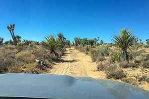 Joshua trees along the Mojave RoadBack on the Road, we continued through Round Valley and soon arrived at the highest point on the Mojave Road at an elevation of 5,174 feet. At the crest, the vegetation was mostly sagebrush, as that is what flourishes at high elevations. Then, as we dropped back down into Cedar Canyon, the vegetation changed to juniper, pinion, and the occasional Joshua tree. I never would have imagined how much variety in plant life there is in the desert.
At mile 62.2, we crossed the Kelso-Cima Road, the last good road we would intersect until Kelbaker Road at Mile 85.5. I wasn’t particularly thrilled with the guide book warnings: “Do not attempt this stretch with only one vehicle. Be sure to have adequate supplies of gasoline and survival provisions.” However, our gas levels looked good and spirits were still high, so we continued on towards this more primitive and isolated section of the road.
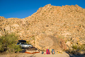 Our favorite campsiteThe next four miles or so were pretty rough, but compensated for by having some of the best scenery so far - Providence Mountains, Kelso, Valley, and Cima Dome.
It was getting close to 3:00, so we starting thinking about finding a place to lay our heads for the night - hopefully in a tent, rather than gasping for breath outside the door of our 4Runner. Fortunately, two of our guidebooks indicated that there there was good camping a short distance down a wash at mile 68.4.
They were right. It was a lovely spot - flat sandy area to pitch a tent, large boulder to shower behind, and great views. The only thing that could have made me happier was a porcelain toilet instead of a shovel.
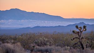 Sunset from our campsiteAfter two days in the desert, a shower sounded pretty good. Fortunately, Herb had brought along one of the best camping-related purchases he has ever made - a helio pressure shower. He filled the bag with water, let the sun heat it up, and then we used a foot pump to power the nozzle to spritz us. It was wonderful. I highly recommend it. It’s only $99.95 on Amazon. I will list it on the right side of the page with the books we recommend.
That evening’s meal consisted of cocktail hour with wine and cheese, followed by powdered Idahoan Roasted Garlic and Parmesan powdered mash potatoes with 2 bags of Starkist Lemony Chicken thrown in. I never thought I would say these words, but it was delicious.
Clean and fed, we took a lovely evening stroll along the wash. There’s nothing like the evening colors in the desert.
- ‹ previous
- 3 of 7
- next ›
Mohave Road - Fort Piute (mile 23.7) to just shy of Marl Springs (mile 77) location map in "high definition"
Javascript is required to view this map.
