- Home
- About
- Map
- Trips
- Bringing Boat West
- Migration West
- Solo Motorcycle Ride
- Final Family XC Trip
- Colorado Rockies
- Graduates' XC Trip
- Yosemite & Nevada
- Colorado & Utah
- Best of Utah
- Southern Loop
- Pacific Northwest
- Northern Loop
- Los Angeles to NYC
- East Coast Trips
- Martha's Vineyard
- 1 Week in Quebec
- Southeast Coast
- NH Backpacking
- Martha's Vineyard
- Canadian Maritimes
- Ocracoke Island
- Edisto Island
- First Landing '02
- Hunting Island '02
- Stowe in Winter
- Hunting Island '01
- Lake Placid
- Chesapeake
- Provincetown
- Hunting Island '00
- Acadia in Winter
- Boston Suburbs
- Niagara Falls
- First Landing '99
- Cape Hatteras
- West Coast Trips
- Burning Man
- Utah Off-Roading
- Maui
- Mojave 4WD Course
- Colorado River Rafting
- Bishop & Death Valley
- Kauai
- Yosemite Fall
- Utah Off-Road
- Lost Coast
- Yosemite Valley
- Arizona and New Mexico
- Pescadero & Capitola
- Bishop & Death Valley
- San Diego, Anza Borrego, Joshua Tree
- Carmel
- Death Valley in Fall
- Yosemite in the Fall
- Pacific Northwest
- Utah Off-Roading
- Southern CA Deserts
- Yosemite & Covid
- Lake Powell Covid
- Eastern Sierra & Covid
- Bishop & Death Valley
- Central & SE Oregon
- Mojave Road
- Eastern Sierra
- Trinity Alps
- Tuolumne Meadows
- Lake Powell Boating
- Eastern Sierra
- Yosemite Winter
- Hawaii
- 4WD Eastern Sierra
- 4WD Death Valley +
- Southern CA Deserts
- Christmas in Tahoe
- Yosemite & Pinnacles
- Totality
- Yosemite & Sierra
- Yosemite Christmas
- Yosemite, San Diego
- Yosemite & North CA
- Seattle to Sierra
- Southwest Deserts
- Yosemite & Sierra
- Pacific Northwest
- Yosemite & South CA
- Pacific Northwest
- Northern California
- Southern Alaska
- Vancouver Island
- International Trips
- Index
- Tips
- Books
- Photos/Videos
- Search
- Contact
Death Valley - Eureka Dunes, CA
Tuesday, April 25, 2017 - 8:00am by Lolo
137 miles and 3 hours from our last stop - 1 night stay
Travelogue
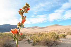 Desert BloomThis was to be a very different type of visit to Death Valley than our previous ones in that we would be heading out to some of its remote areas in our Subaru Forester.
As one should always do before heading out on 4WD roads, we stopped at the Furnace Creek Visitor Center to discuss road conditions with a ranger and to get some advice as to what would be appropriate for us. Although our Subaru is very capable off road, it’s not exactly a rock crawler, nor are its tires as beefy as the trucks devoted to this sport.
We originally thought we would drive out to the Racetrack, where the rocks mysteriously move when no one is looking, but the ranger told us that our tires would be eaten up by the rocks in no time, and we would most likely have to be towed out. Okay, forget that idea.
However, he did give us two good suggestions – the 40-mile drive to Eureka Dunes and/or also the 40-mile drive down the Saline Valley to the hot springs, both of which he felt our Subaru could handle without a problem. He even said that if we left soon, we should be able to get to Eureka Dunes with several hours of daylight to spare.
 Crankshaft Junction on the way to Eureka DunesWe left the Visitor Center and headed north towards Scotty’s Castle. When we came to the junction for Scotty’s Castle/Ubehebe Crater, we took a left towards the crater. Actually, we had no choice as the road to Scotty’s Castle was so damaged by storms that it is closed, and expected to be so for quite some time. Rather than going all the way to the crater, at about 2.8 miles after the junction we turned right onto the Death Valley / Big Pine Road.
The dirt-and-gravel Big Pine Road was well-maintained and definitely navigable for a 2WD vehicle. At about the 18 mile point, we came to our first landmark – Crankshaft Junction, named for the castoff engine parts that less-fortunate travelers left at this remote site. It made you think a little bit.
We continued on for another 12 miles before turning left onto the South Eureka Road to the dunes. The road was a bit rougher and sandier than the Big Pines Road, but comfortably doable in our 4WD Subaru Forester. I’m not sure if it is advisable with 2WD, but that could certainly be confirmed by talking to a ranger.
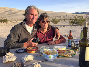 Cocktail hour at Eureka DunesIt was another 10 miles along the South Eureka Road to the campground near the base of the very impressive Eureka Dunes, the largest dune in California and the second largest in the entire U.S. The campground was dry (no water or flush toilets) and had only four designated sites. Fortunately, there was one left, which we grabbed. A bit further down the road, there are a few more dispersed campsites without the amenities of a picnic table and fire ring.
As striking as the dunes were, an even lovelier view from our campsite was of the Last Chance Mountains, rising 700 feet from the Eureka Valley floor, brightly painted by the evening light.
We spent a lovely evening, enhanced with wine and cheese, with our very interesting camping neighbor David, a professional photographer that currently lives in India in the same village as the Dalai Lama. He was visiting the states for two months because his photographs are being exhibited at several galleries throughout the country. Later that evening, he went back to his camper and returned with a copy of his recently published book, a stunning collection of portraits of Tibetan migrants. We were honored when he offered to take our photo with my cell phone.
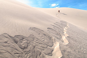 Making the dunes singThe next morning, Herb and I set out on our hike up the dune, an exercise I always find more grueling than anticipated – 2 steps forward, 1 step back. Plus, although we did get a relatively early start in the morning, it was already getting pretty hot up there.
It was actually a little tricky finding the summit, as each time we climbed to the top of a ridge, we saw another one higher. The guidebook said that it was 700 feet high, so we kept track of our progress on Herb’s altimeter watch.
There were portions of the hike that were so steep that I actually had to bend my body forward into the incline and use my hands as well. I looked like a gorilla. Meanwhile, each step on the really steep parts set off what looked like a river of sand, starting about 3 feet above us and continuing right below us for another dozen or so feet. The patterns we created were beautiful.
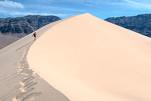 Almost thereBesides the intriguing visual effect, we were also making the dunes “sing.” Singing sand dunes are quite rare and there are only about 40 of them in the entire world. The singing is really more of a booming sound, and it is triggered by an avalanching movement of sand.
After a few false summits, Herb’s altimeter watch eventually showed a gain of 690 feet – good enough. We looked around and saw no higher ridge, so we declared ourselves at the top.
The way down was a heck of a lot more fun and took about a third of the time it took us on the way up. I felt like I was running down a hill of pudding.
All in all, the hike was a very rewarding, and exhausting, 2.1 mile round-trip.
Description
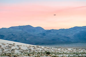 Desert Sunset with "Leonard the Drone"The Eureka Dunes are located in an enclosed basin at 3,000 foot elevation in the northwest corner of Death Valley National Park. Rising 700 feet above sea level, they are the tallest sand dunes in California and possibly the tallest in all of North America.
They are reached via a series of rutted dirt and gravel roads subject to washout, so reaching this area requires a 4WD vehicle.
The climb to the summit is about 2 miles (RT) and should be done early in the day or later in the evening when the temperature is cooler. The climb to the summit is challenging, as the slopes are steep and the loose sand gives way beneath your feet. During the steepest parts of the hike, the sand avalanches in rivulets and begins to sing. This “singing sand” phenomena, resulting from the friction of the sand grains sliding against each other, sounds like the bass note of a pipe organ. The views at the top are worth the struggle to get there.
As tall as these impressive dunes are, they are dwarfed by the colorfully striped limestone walls of the Last Chance Mountains, which rise 4,000 feet above the valley floor.
- ‹ previous
- 3 of 8
- next ›
Death Valley - Eureka Dunes location map in "high definition"
Javascript is required to view this map.
