- Home
- About
- Map
- Trips
- Bringing Boat West
- Migration West
- Solo Motorcycle Ride
- Final Family XC Trip
- Colorado Rockies
- Graduates' XC Trip
- Yosemite & Nevada
- Colorado & Utah
- Best of Utah
- Southern Loop
- Pacific Northwest
- Northern Loop
- Los Angeles to NYC
- East Coast Trips
- Martha's Vineyard
- 1 Week in Quebec
- Southeast Coast
- NH Backpacking
- Martha's Vineyard
- Canadian Maritimes
- Ocracoke Island
- Edisto Island
- First Landing '02
- Hunting Island '02
- Stowe in Winter
- Hunting Island '01
- Lake Placid
- Chesapeake
- Provincetown
- Hunting Island '00
- Acadia in Winter
- Boston Suburbs
- Niagara Falls
- First Landing '99
- Cape Hatteras
- West Coast Trips
- Burning Man
- Utah Off-Roading
- Maui
- Mojave 4WD Course
- Colorado River Rafting
- Bishop & Death Valley
- Kauai
- Yosemite Fall
- Utah Off-Road
- Lost Coast
- Yosemite Valley
- Arizona and New Mexico
- Pescadero & Capitola
- Bishop & Death Valley
- San Diego, Anza Borrego, Joshua Tree
- Carmel
- Death Valley in Fall
- Yosemite in the Fall
- Pacific Northwest
- Utah Off-Roading
- Southern CA Deserts
- Yosemite & Covid
- Lake Powell Covid
- Eastern Sierra & Covid
- Bishop & Death Valley
- Central & SE Oregon
- Mojave Road
- Eastern Sierra
- Trinity Alps
- Tuolumne Meadows
- Lake Powell Boating
- Eastern Sierra
- Yosemite Winter
- Hawaii
- 4WD Eastern Sierra
- 4WD Death Valley +
- Southern CA Deserts
- Christmas in Tahoe
- Yosemite & Pinnacles
- Totality
- Yosemite & Sierra
- Yosemite Christmas
- Yosemite, San Diego
- Yosemite & North CA
- Seattle to Sierra
- Southwest Deserts
- Yosemite & Sierra
- Pacific Northwest
- Yosemite & South CA
- Pacific Northwest
- Northern California
- Southern Alaska
- Vancouver Island
- International Trips
- Index
- Tips
- Books
- Photos/Videos
- Search
- Contact
Lee Vining (Mono Lake), CA
Monday, April 24, 2017 - 6:45pm by Lolo
300 miles and 5.5 hours from our last stop - 1 night stay
Travelogue
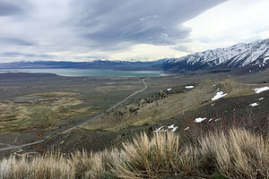
 Approach to Mono LakeBecause of the record-breaking snowfall in the Sierras this past winter, the only way to get across the Sierras (besides going all the way down to Bakersfield) was Route 50 through South Lake Tahoe.
As a New Jerseyite for 60 years, I am still intrigued by this idea of “going to the snow,” where you can literally drive from 80 degree sunny weather to a winter wonderland within 4 hours. As we drove through the tiny town of Kyburz on 50, more and more snow appeared on the sides of the road. It even hailed on us for a good part of the way.
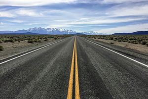
Eventually we crossed over and started heading down 395, also known as the Eastern Sierra Scenic Byway – and for good reason. For most of our drive, we had jaw-dropping views of snow-covered mountains both to west and east.
 Herb relaxing in the Lake View LodgeKnowing we would not get to Death Valley that first day, we stopped at a motel in Lee Vining for the night. It was unseasonably cold and so windy that there were white caps on Mono Lake. We had hoped to eat at our favorite gas station (Whoa Nellie Deli), but were told that it was still closed for the season until the following week. The town was pretty much dead, so we made do for dinner with supplies from our cooler.
Lee Vining is worthy of much more than a mere drive there. It is in a beautiful location with so many wonderful things to do. I have tried to describe some of them in the Description section of this stop (see Tab above).
Description
 Sierra BoundLee Vining is a small town along the Eastern Sierra Scenic Byway (Highway 395) located on the southwest shore of Mono Lake and the eastern entrance to Yosemite National Park.
Some highlights in the area include:
Mono Lake
Mono Lake is located just off Highway 395 near the town of Lee Vining, California, 13 miles east of Yosemite National Park. Mono Lake is extremely unique. First of all, at over 1 million years of age, it is one of the oldest continuously existing lakes in the continent. Secondly, it is about 2 ½ times as salty as the sea and about 80 times as alkaline. This is because Sierra streams flow into Mono Lake bringing trace amounts of salts and minerals, but the lake has no outlet other than evaporation. As a result, the concentration levels of salts and minerals keeps growing each year. Thirdly, and the main reason Mono Lake is so popular, are the hundreds of spectacular “tufa towers” that rise from the lake. These intriguing calcium-carbonate sculptures were formed beneath the water when carbonates in the water combined with calcium from freshwater springs feeding into the lake. As lake levels dropped, these extraordinary-looking knobs, spires, and minarets became exposed. Most of the towers visible in the lake are from 200 to 900 years old and rise as high as 30 feet above the water.
Panum Crater is a small, dormant crater located just south of Mono Lake and east of Highway 395. The Crater, which last erupted in 1325 AD, is a perfect example of a rhyolitic plug-dome volcano. A marked and maintained trail leads around the rim of the crater, with spectacular views of the Eastern Sierras, Mono Lake and the Mono Basin. The crater is about 2,000 feet across. A side trip leads down into the lava dome at the center of the volcano where there are bizarre rock formations and huge chunks of obsidian everywhere. The rim and trail into the dome is about 2 ½ miles long with a total elevation gain of about 200 feet.
Black Point is a flat-topped volcanic hill on the north side of Mono Lake. It last erupted about 13,000 years ago beneath the waters of what was once a much deeper Mono Lake. As the cinders and lava cooled and hardened under water, the top split open to form several hundred-yard-long cracks, or canyon-like fissures, measuring from 20 to 50 foot deep and only a few feet wide. When the waters of Mono Lake receded after the Ice Age, Black Point became a peninsula. It is the only fully exposed underwater volcano on earth.
There really is no trail to the Black Point Fissures, and they can be challenging to find because they are not visible until you are standing at their edge. The best thing to do is to start at the BLM trailhead and follow the lines of footprints up the gently sloping butte across cinders and ash to the level plateau on top of the point. The fissures can be found about 800 feet beyond the small rocky promontory near the southeast corner, radiating northwards away from a small line of cliffs along the south edge of the summit plateau.
All the fissures have sloping sides so they can be entered without much difficulty. Be sure to do so to see the unusual knobby textures and colors along their walls.
On the way down, expansive views of Mono Lake and the Sierras lie before you.
Lundy Canyon is located about seven miles north of Lee Vining, along the eastern boundary of Yosemite National Park. The Lundy Canyon trail is the backdoor into the 20 Lakes Basin area of the Hoover Wilderness and along its way are some of the best waterfalls in the Eastern Sierras. The trailhead is located at the end of Lundy Lake Road, about 2 miles past Lundy Lake. Although the entire trail goes to Saddleback Lake (in 6 miles), most people turn around at 2.2. miles when the trail becomes much steeper and treacherous alongside a steep wall of unstable shale. For much of the hike, the trail rises alongside Mill Creek, passing several beaver ponds, lower Lundy Falls near the beginning of the trail, and the Upper Falls near the turnaround point where the trail begins to climb out of the canyon.
- 1 of 8
- next ›
Lee Vining (Mono Lake) location map in "high definition"
Javascript is required to view this map.
