- Home
- About
- Map
- Trips
- Bringing Boat West
- Migration West
- Solo Motorcycle Ride
- Final Family XC Trip
- Colorado Rockies
- Graduates' XC Trip
- Yosemite & Nevada
- Colorado & Utah
- Best of Utah
- Southern Loop
- Pacific Northwest
- Northern Loop
- Los Angeles to NYC
- East Coast Trips
- Martha's Vineyard
- 1 Week in Quebec
- Southeast Coast
- NH Backpacking
- Martha's Vineyard
- Canadian Maritimes
- Ocracoke Island
- Edisto Island
- First Landing '02
- Hunting Island '02
- Stowe in Winter
- Hunting Island '01
- Lake Placid
- Chesapeake
- Provincetown
- Hunting Island '00
- Acadia in Winter
- Boston Suburbs
- Niagara Falls
- First Landing '99
- Cape Hatteras
- West Coast Trips
- Burning Man
- Utah Off-Roading
- Maui
- Mojave 4WD Course
- Colorado River Rafting
- Bishop & Death Valley
- Kauai
- Yosemite Fall
- Utah Off-Road
- Lost Coast
- Yosemite Valley
- Arizona and New Mexico
- Pescadero & Capitola
- Bishop & Death Valley
- San Diego, Anza Borrego, Joshua Tree
- Carmel
- Death Valley in Fall
- Yosemite in the Fall
- Pacific Northwest
- Utah Off-Roading
- Southern CA Deserts
- Yosemite & Covid
- Lake Powell Covid
- Eastern Sierra & Covid
- Bishop & Death Valley
- Central & SE Oregon
- Mojave Road
- Eastern Sierra
- Trinity Alps
- Tuolumne Meadows
- Lake Powell Boating
- Eastern Sierra
- Yosemite Winter
- Hawaii
- 4WD Eastern Sierra
- 4WD Death Valley +
- Southern CA Deserts
- Christmas in Tahoe
- Yosemite & Pinnacles
- Totality
- Yosemite & Sierra
- Yosemite Christmas
- Yosemite, San Diego
- Yosemite & North CA
- Seattle to Sierra
- Southwest Deserts
- Yosemite & Sierra
- Pacific Northwest
- Yosemite & South CA
- Pacific Northwest
- Northern California
- Southern Alaska
- Vancouver Island
- International Trips
- Index
- Tips
- Books
- Photos/Videos
- Search
- Contact
Lone Pine, CA
Saturday, July 21, 2007 - 7:15am by Lolo
80 miles and 1.5 hours from our last stop
Travelogue
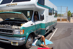
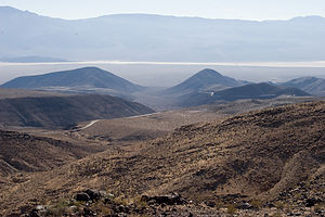
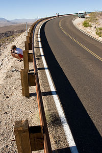
 Dad fixing brakes - TJGThe western route out of Death Valley was much steeper and twisting than we had anticipated, but quite beautiful as the Death Valley ranger had said. After a particularly intense series of twists and turns, we pulled over to enjoy the view and to let our brakes take a well-need rest. That’s when Herb discovered that he could press the brake pedal all the way down to the floor with little or no resistance. We waited a bit to see if letting them cool off would help, but to no avail.
We weren’t sure what to do. The options weren’t that great. Having the RV towed out of Death Valley to some semblance of civilization would probably cost more than our entire vacation. Driving it as is wasn’t particular appealing either.
We turned on the laptop and looked at our map program to see how far away we were from the next town. The news wasn’t good. The nearest town was Lone Pine, and it was about 25 or 30 miles away. However, there was some good news as well. The road from here to Lone Pine was straight as an arrow, meaning that the mountains and twisting turns were behind us and we were into the flatlands.
 Road out of Death ValleyWe decided to go for it—driving slowly and downshifting to slow us down. Fortunately, the road was perfect for this—straight, flat, and totally devoid of other vehicles. I don’t think we passed another car the whole 25 miles. Still, it was quite tense.
At one point I glanced back at the boys in the rear of the RV and saw them contentedly watching a Seinfeld episode on TV. They were oblivious to the situation. We decided not to ruin it for them.
Eventually, we saw the intersection for US 395 (which is also the Main Street of Lone Pine) up ahead and slowly coasted and downshifted to a stop at the light. We noticed a Visitor Center on our left, so we pulled in to inquire about where we could get some mechanical assistance for our problem.
Mind you, it was already lunch time on Saturday, and since nothing was going to be open on Sunday, time was of the essence. Also, the family had gotten quite cranky about the blistering heat of the past few days and was very much looking forward to our stay in Yosemite Valley, which was supposed to begin that evening.
 Lazy Daze without brake fluid at turnoutAt the Visitor Center, we found that our choices were the lone mechanic in town (I’m sure his prices would be cheap) or a NAPA auto parts store. As I expected, Herb who is definitely a do it yourself kind of guy, decided to go the NAPA route. We slowly inched our way through town and pulled into a parking lot right across the street from the NAPA.
Herb took out some old towels and crawled under the RV to assess the situation, while we all anxiously gathered round to hear the verdict. The sounds we heard from beneath the RV were definitely not good. It was probably about as bad as it could get—the right rear brake line had rusted and split opening, explaining why we had lost all our brake fluid. I think this was a bigger job than even Herb anticipated, but we were all so used to him being able to fix everything that we just assumed everything would be okay and that we would be on our way in a few hours.
The boys went off on a run, while Herb and I went over to the NAPA to see what could be done. As we expected, they didn’t have a direct replacement for the brake line, but they did have the parts to kludge one. While they began working on that, Herb went back across the street to crawl under the RV and remove the old brake line. Poor Herb. It was about 105 degrees out and the brake line was not coming out easily because of a lot of rusting. However, Herb finally did manage to get it out, as I knew he would, and brought it across the street to the NAPA. Meanwhile, the clock was ticking away. It was already 3:00 and the NAPA store was closing at 5:00. The guys in the store were great, but I’m sure they didn’t plan on wasting their Saturday night on our brake line. The kludging of the new brake line got pretty tense at one point, when the only steel tube they had in stock had to be bent into position. If it broke, we would be spending a good deal more of our vacation in Lone Pine than we wanted to.
Not that Lone Pine isn’t nice. It really is. There is a great view of Mt. Whitney from the corner by the NAPA store. In fact, Ansel Adams took one of his famous shots of Mt. Whitney from this very town. However, we still really wanted to be in Yosemite by bedtime.
Thankfully, the construction of our new brakeline went off without a hitch. The NAPA men had done their part and now it was up to poor Herb to install it. He’s definitely my hero. He worked the rest of the afternoon in the blistering heat and got us to Yosemite Valley before midnight.
What a day, but it could have been a lot worse. Herb had nightmares that night of losing the brakes while going down the steep descents out of Death Valley. He was going to really need this week in Yosemite to recover.
Description
The town of Lone Pine (population 1,655), located on California Highway 395, is a popular tourist destination because of its proximity to so many major attractions, such as Mount Whitney, Death Valley, Kings Canyon National Park, Sequoia National Park, and Yosemite. There are views of 14,496 foot high Mount Whitney, the highest mountain in the continental United States, right from town. In fact, one of Ansel Adams’ most famous prints is a photograph of the mountain taken from the town.
Although its Wild West days are long gone, Lone Pine’s unspoiled scenery has lived on in more than 250 Hollywood film and TV shows, such as the Lone Ranger and Roy Rogers. At the Alabama Hills Recreation Area, just west of town on the Whitney Portal Road, you might recognize the strange rock formation that rise from the valley floor from one of the many Westerns that were filmed here. Today the towns movie roots continue at the Lone Pine Film Festival held here each October.
Just north of Lone Pine on 395 is the Manzanar National Historic Site, a Japanese American internment camp during the Second World War. During the war, more than 100,000 Japanese Americans were rounded up and forcefully departed to various internment camps throughout the West. This monument serves as a reminder of that very shameful chapter of our nation’s history.
- ‹ previous
- 8 of 19
- next ›
Lone Pine location map in "high definition"
Javascript is required to view this map.

Great website. Too bad your schedule didn't leave time to visit the Alabama Hills that lie between Lone Pine and Mt Whitney or the Lone Pine Film History museum. The Alabama Hills are a very unique place where hundreds of movies and TV shows have been filmed and the museum is a tribute to that. One of the most recent films shot there was Iron Man.
For more, go here:
http://www.openroad.tv/index.php?categoryid=16&p25_id=7
There are lots of other great places along US 395 featured on the above website too. You can see a few of my own pix from a trip I did earlier this year here:
http://picasaweb.google.com/schmidt.ar/California2008Panoramas
and here:
http://picasaweb.google.com/schmidt.ar/California2008
Cheers
Thanks for the tip Arthur. Next time out we will definitely check out the Alabama Hills. Nice photos too. You've motivated me to try to generate some panoramas myself.
Safe Travels
Love your site. I made the same drive through Death Valley in April of this year (spring break) in our 32 foot RV with our kids. While I was winding my way through the twists and turns and staring at some of those rock faces next to the road, my wife says "did you see that sign that said this road was not recommended for vehicles over 30 feet?" My response was "Huh?" Needless to say, we made it out without any problem. Luckily there's was no oncoming traffic so I could take wider turns. The ride into Lone Pine was very pretty. We stopped for gas there and continued up to Carson City. -Tito
Hi Tito,
I didn't catch the sign warning about any length restrictions, though with a 26.5' motorhome I guess it wouldn't have been an issue. I managed to crawl along into Lone Pine using the transmission as a brake... maybe next time I'll be able to enjoy the view! Safe Travels - Herb
Yeah Herb!!! As another confirmed DIYer, congrats on "GitInErDone"
Jim
Thanks Jim,
This was certainly my most stressful travel day due to mechanical RV failures. In and effort to avoid this sort of thing in the future I've just replaced the rest of the brake lines which lead to the rear of the RV, as well as all new rubber hoses, brakes, and calipers. (At 90k miles I've also just flushed the radiator coolant, ATF Fluid, rear differential oil, and serpentine belt.)
Herb